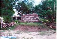
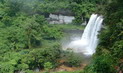
General Information Phu Singh-Phu Pha Pheung Forest Park located in Nok Tha Sub-district, Lao Pruan Sub-district and Keum Yai Sub-district in Muang District; and Non Ngam Sub-district, Pathum Ratchawongsa, Amnat Charoen Province, situated in Dong Bung Ei-Dong Hua Kong National Reserved Forest, covered the area of approximately 10,000 rais. The Royal Forest Deaprtment declared this forest park on August 26, 1996.
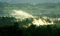
Topography It’s mountain range, 200-300 metres above the average sea level. Some part of it is large stone ground and high cliff. There are many small and medium-sized caves. It’s a watershed area for Huay Sii Toh Stream and Huay Sai
Stream.
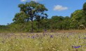
Flora and Fauna Because the area is full of sandy soil and large amount of rock, therefore its forest mostly is Dry Deciduous Dipterocarp Forest combined with Mixed Deciduous Forest. This cause those trees grown become strong and well stand to the drought, for instance Shorea obtusa, Shorea siamensis, Afzelia xylocarpa, Sindora siamensis, Xylia xylocarpa, Lagerstroemia sp., Pterocarpus macrocarpus, Bambusa arundinacea and Morinda sp. Fauna found consists of jungle fowl, bird, jackal and common
reptiles.
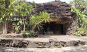
Tham Yao Cave Tham Yao Cave is a big sandstone cave. It used to be a shelter for communism terrorists in the
Northeast.
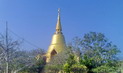
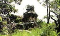
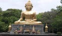
Buddha Image on the top of Phu Pha Pheung Mountain Buddha Image on the top of Phu Pha Pheung Mountain is a mortar Buddha image practicing meditation that is respected by local
people.
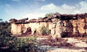
Phu Pha Pheung Cliff Phu Pha Pheung Cliff is so called because of its characteristic that bees nested inside the
cliff.
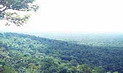
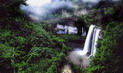
Phu Pha Song Phu Pha Song is a view point cliff where you can see the panorama
view.
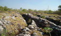
Ang Kob Ang Kob is caused by stone phenomenon called Pot Hole. It’s happened when sand and small stones within the hole have been eroded by the flow. This has been continually happened for hundreds years until the hole has become deeper and bigger
eventually.
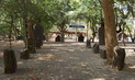
The Trails on Phu Pha Pheung The trails on Phu Pha Pheung will take you to many view points where you can see various unique flora species grown both on trees and on the
ground.
The Huge Sandstone The Huge Sandstone is like frog or turtle, depends on when you have been watching it from different
angle.
How to go? By Car About 14 kms from Amnat Charoen by the asfalt road, you can turn left to the dirt road that will lead you to the forest area. Drive further for about 6 kms, you will arrive the forest park. The road to the forest park can be accessed in all season. Th forest park is about 18 kms away from Ubon
Ratchathani.
Amnat Charoen is located in Southern I-San plateau approximately 583 kilometres from Bangkok. It is a newly established province upgraded from Amphoe Amnat Charoen of Ubon Ratchathani Province in 1993.
The province is divided into the following districts: Mueang, Chanuman, Phana, Hua Taphan, Senangkhanikhom, Pathum Ratchawongsa and Lue Amnat.
How to get there
Car
From Bangkok, take Highway No. 1 to Saraburi and Highway No. 2 to Nakhon Ratchasima, then take Highway No. 226 to Buriram and Surin and continue the journey along Highways No. 214 and 202 to Amnat Charoen via Suwannaphum and Yasothon, a total distance of 585
kilometres.
Bus
Buses depart from Mochit 2 Bus Terminal to Amnat Charoen every day. Contact Transport Co.Ltd at Tel: 0 2936 2852-66 for more information
Rail
There is no direct train to Amnat Charoen. Visitors can take a train to Ubon Ratchathani, then continue the trip by bus to Amnat Charoen. Call 1690, 0 2223 7010-20 for more
information.
Air
Thai Airways flies from Bangkok to Ubon Ratchathani, which is 75 kilometres from Amnat Charoen. Call 1566, 0 2280 0060, 0 2628 2000 for more
information.
Festivals
Boat Racing
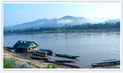
This festival is held around November in front of the Chanuman district office nearby the Mekong River. The festival draws decorative boats from neighbouring provinces and Lao
P.D.R.
Long Kuang
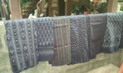
This tradition is a gathering of unmarried male and female villagers. Females weave along with musical tunes conducted by male villagers.
Amnat Charoen is located in Southern I-San plateau approximately 583 kilometres from Bangkok. It is a newly established province upgraded from Amphoe Amnat Charoen of Ubon Ratchathani Province in 1993.
The province is divided into the following districts: Mueang, Chanuman, Phana, Hua Taphan, Senangkhanikhom, Pathum Ratchawongsa and Lue Amnat.
How to get there
Car
From Bangkok, take Highway No. 1 to Saraburi and Highway No. 2 to Nakhon Ratchasima, then take Highway No. 226 to Buriram and Surin and continue the journey along Highways No. 214 and 202 to Amnat Charoen via Suwannaphum and Yasothon, a total distance of 585 kilometres.
Bus
Buses depart from Mochit 2 Bus Terminal to Amnat Charoen every day. Contact Transport Co.Ltd at Tel: 0 2936 2852-66 for more information
Rail
There is no direct train to Amnat Charoen. Visitors can take a train to Ubon Ratchathani, then continue the trip by bus to Amnat Charoen. Call 1690, 0 2223 7010-20 for more information.
Air
Thai Airways flies from Bangkok to Ubon Ratchathani, which is 75 kilometres from Amnat Charoen. Call 1566, 0 2280 0060, 0 2628 2000 for more information.
Festivals
Boat Racing
This festival is held around November in front of the Chanuman district office nearby the Mekong River. The festival draws decorative boats from neighbouring provinces and Lao P.D.R.
Long Kuang
This tradition is a gathering of unmarried male and female villagers. Females weave along with musical tunes conducted by male villagers.


 ข้อมูลทั่วไป
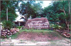


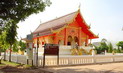
 พุทธอุทยานและพระมงคลมิ่งเมือง